Introduction
Bulbophyllum Thouars is a genus of perennial plants belonging to the family Orchidaceae. This genus has approximately 700 species distributed globally. Two such species have been found in South Korea: B. inconspicuum Maxim. (commonly known as barley orchid or cyst orchid, reflecting the cyst-like shape of the fake bulb on a single leaf) and B. drymoglossum Maxim. ex M. Okubo (Lee, 2006). The Ministry of Environment has designated these species as vulnerable (VU) species for protection. B. drymoglossum and B. inconspicuum were designated as new Class II Endangered Species for more rigorous protection in 2012 and 2017, respectively.
B. drymoglossum and B. inconspicuum are distributed mainly in islands along the southwest coast of South Korea, including Jejudo, where their indiscriminate collection and destruction of natural habitat seriously threaten their survival (National Institute of Biological Resources (NIBR), 2018). The recent National Survey on the Distribution of Endangered Species reported the presence of a large-scale natural habitat of B. inconspicuum in Hongdo, Shinan-gun, Jeonnam Province. The entire island of Hongdo was designated as a natural reserve (Natural Heritage No.170) in 1965. It is an important location in terms of biodiversity preservation and academic research of the flora and community structure of evergreen broadleaf forest in warm and temperate climate (Lee et al., 2011).
Hongdo is part of the Dadohae National Marine Park. While the total area of the park is only 6.47 km2, the island is rich in flora and fauna. It harbors several rare plant resources as well as unusual pediments and scenic areas (Lee, 2014). Hongdo is a valuable academic resource with a unique environment based on geographic and topographic characteristics (Kim et al., 2016). The present field investigation in Hongdo was performed to obtain population data, distribution data, and characteristics of B. inconspicuum.
Materials and Methods
Survey area
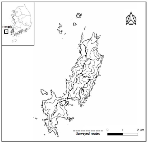
The administrative district of Hongdo is present in Heuksan-myeon, Shinan-gun, Jeonnam Province, Korea. It is located at 125°10′35″ E–125°13′14″ E and 34°39′43″ N–34°43′23″ N, 115 km west of Mokpo and 22 km west of Daeheuksan-do (Shin & Kim, 1996) (Fig. 1). The total area of the island is 6.47 km2. The topography of the entire island features a major axis from northeast to southwest, with Gitdaebong (367 m) as the highest peak on the northeast and Yangsanbong (236 m) as that on the southwest, which surrounds the village of Hongdo-1-gu. Based on floristics, the area belongs to the south coast plant zone (Lee & Yang, 1978). Its annual mean temperature from 2011 to 2020 was 14.17℃. Its annual mean precipitation during that period was 1,029.5 mm, with the highest precipitation levels observed between June and September (Korea Meteorological Administration (KMA), 2020).
Methods
All natural habitats of B. inconspicuum distributed in Hongdo as found in the National Survey on the Distribution of Endangered Species were reconfirmed. The natural habitat and attachment substrate of B. inconspicuum were investigated from May 2019 to May 2021. Plant species were identified using Coloured Flora of Korea (Lee, 2003) and New Flora of Korea (Lee, 2006).
Results and Discussion
Regional distribution of B. inconspicuum in previous studies
A literature review revealed that B. inconspicuum was distributed over approximately 13 locations in Hongdo. The Korea National Arboretum ( reported that the species inhabited rocks in fewer than 10 sunny areas (KNA, 2008). The National Survey on the Distribution of Endangered Species reported that three areas were inhabited. However, as a characteristic of endanger ed species, precise locations of these areas could not be determined except for the three areas in the National Survey on the Distribution of Endangered Species.
Field investigation
Hongdo was broadly divided into three regions for investigation. Region 1 comprised Hongdo 1 gu to Yangsanbong. The tree layer included Castanopsis sieboldii, Machilus thunbergii, and Pinus densiflora. The subtree layer and shrubs included Camellia japonica, Euonymus oxyphyllus, and Dendropanax morbiferus. The herb layer included Trachelospermum asiaticum, Arisaema amurense, Farfugium japonicum, Ophiopogon jaburan, and Arachniodes aristata. Region 2 comprised Hongdo 1 gu to Gitdaebong. The tree layer included C. sieboldii, M. thunbergii, and Quercus acuta>. The subtree layer and shrubs included Ligustrum japonicum, E. japonicus>, and Camellia japonica. The herb layer included T. asiaticum, Calanthe striata, Damnacanthus indicus, Goodyera schlechtendaliana, and Eurya japonica. Region 3 comprised Gitdaebong to Hongdo-2 gu. The tree layer included M. thunbergii, C. sieboldii>, and C. japonica. The subtree layer and shrubs included C. japonica, L. japonicum, and E. japonicus. The herb layer included F. japonicum, Lemma phyllum microphyllum, T. asiaticum, and E. japonicus. In addition, cliffs along the coast and bare rocks had a community of P. densiflora, while a community of Carpinus turczaninowii was found on ridge protrusions and boulder slopes.
Region 1 (Hongdo-1-gu to Yangsanbong)
C. sieboldii and M. thunbergii were dominant species while B. inconspicuum was not found. However, villagers rarely entered this region. Edges of the coastal cliffs could not be investigated due to safety reasons. With the aid of a cliff e xpert using a drone and safety devices, species belonging to the Orchidaceae family, such as Neofinetia falcata and Dendrobium moniliforme including B. inconspicuum, might be found in the future.
Region 2 (Hongdo-1-gu to Gitdaebong)
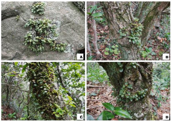
C. sieboldii, M. thunb ergii, and Q. acuta were dominant species. Their presence in three previously reported habitats was reconfirmed. Thirty seven new habitats of B. inconspicuum were identified (Table 1). Newly observed B. inconspicuum were naturally growing on rocks and plan ts. They included Q. mongolica, Rhaphiolepis indica var. umbellata, and C. turczaninowii as substrates (Fig 2). B. inconspicuum was mainly distributed at altitudes greater than 250 m. The plant mostly grew attached to the bottom of rocks or branches and roots at the base of trees with a height of 1 m or less. Notably, a dense distribution of the species was found on the southeast and southwest slopes of specific ridges that surrounded Gitdaebong.
Table 1.
| No. | GPS | Elevation (m) | Type of substrate | Population | |
|---|---|---|---|---|---|
| 1 | 34°41'00''*** | 125°11'59''*** | 331 | QM | ≥ 100 |
| 2 | 34°41'00''*** | 125°11'59''*** | 330 | QM | ≥ 100 |
| 3 | 34°41'00''*** | 125°11'59''*** | 331 | QM | ≤ 30 |
| 4 | 34°41'00''*** | 125°11'59''*** | 331 | Rock | ≤ 10 |
| 5 | 34°41'00''*** | 125°11'59''*** | 332 | RU+Rock | ≤ 50 |
| 6 | 34°41'00''*** | 125°11'59''*** | 331 | CT | ≤ 20 |
| 7 | 34°41'00''*** | 125°11'59''*** | 330 | QM | ≤ 20 |
| 8 | 34°41'00''*** | 125°11'59''*** | 329 | CT | ≤ 50 |
| 9 | 34°41'00''*** | 125°11'59''*** | 331 | QM | ≥ 100 |
| 10 | 34°41'00''*** | 125°11'59''*** | 334 | RU | ≤ 20 |
| 11 | 34°41'00''*** | 125°11'59''*** | 335 | CT | ≤ 5 |
| 12 | 34°41'00''*** | 125°11'59''*** | 337 | CT | ≤ 30 |
| 13 | 34°41'00''*** | 125°11'59''*** | 336 | RU | ≤ 20 |
| 14 | 34°41'00''*** | 125°11'59''*** | 336 | CT+RU | ≤ 25≤ 25 |
| 15 | 34°41'00''*** | 125°11'59''*** | 337 | CT | ≤ 20 |
| 16 | 34°41'00''*** | 125°11'59''*** | 333 | RU | ≤ 30 |
| 17 | 34°41'00''*** | 125°12'00''*** | 335 | RU | ≤ 10 |
| 18 | 34°41'00''*** | 125°12'00''*** | 330 | CT | ≤ 20 |
| 19 | 34°41'00''*** | 125°12'00''*** | 330 | CT | ≥ 100 |
| 20 | 34°41'00''*** | 125°12'00''*** | 328 | QM | ≥ 100 |
| 21 | 34°41'00''*** | 125°12'00''*** | 330 | RU | ≤ 50 |
| 22 | 34°41'00''*** | 125°12'00''*** | 330 | CT | ≤ 20 |
| 23 | 34°41'00''*** | 125°12'00''*** | 332 | QM | ≤ 50 |
| 24 | 34°41'00''*** | 125°12'00''*** | 330 | RU | ≤ 30 |
| 25 | 34°41'00''*** | 125°12'02''*** | 328 | CT | ≤ 25 |
| 26 | 34°41'00''*** | 125°12'02''*** | 326 | QM | ≤ 20 |
| 27 | 34°41'00''*** | 125°12'02''*** | 326 | CT | ≤ 20 |
| 28 | 34°41'00''*** | 125°12'02''*** | 321 | RU | ≤ 30 |
| 29 | 34°41'00''*** | 125°12'13''*** | 257 | Rock | ≤ 20 |
| 30 | 34°41'00''*** | 125°12'10''*** | 292 | Rock | ≤ 30 |
| 31 | 34°41'00''*** | 125°12'07''*** | 203 | Rock | ≤ 15 |
| 32 | 34°41'00''*** | 125°12'07''*** | 242 | RU | ≤ 10 |
| 33 | 34°41'00''*** | 125°12'08''*** | 245 | Rock | ≤ 10 |
| 34 | 34°41'00''*** | 125°12'11''*** | 218 | Rock | ≤ 30 |
| 35 | 34°41'00''*** | 125°12'07''*** | 205 | Rock | ≤ 50 |
| 36 | 34°41'00''*** | 125°12'14''*** | 216 | Rock | ≤ 20 |
| 37 | 34°41'00''*** | 125°12'19''*** | 157 | Rock | ≤ 30 |
| Previous known | 34°41'28''*** | 125°12'13''*** | 262 | Rock | ≤ 30 |
| 34°41'29''*** | 125°12'02''*** | 325 | Rock | ≥ 100 | |
| 34°41'00''*** | 125°12'59''*** | 265 | CT | ≥ 100 | |
QM:Quercus mongolica, CT: Carpinus turczaninowii, RU: Rhaphiolepis indica var. umbellata
Fig. 2.

As few as 10 up to hundreds of plants were found growing in clust ers in certain areas with D. moniliforme, a Class II Endangered Species. Close to their habitat, C. striata, C. aristulifera, and C. × kibanakirishima were found, implying a high probability of illegal collection of multiple endangered species, including B. inconspicuum. Edges of the coastal cliffs could not be investigated due to safety reasons. Many more plants and various endangered species might be detected in future studies with the aid of a cliff expert.
Region 3 (Gitdaebong to Hongdo-2-gu)
C.sieboldii and M. thunbergii were dominant species in this region that mainly comprised northwest slopes with Gitdaebong at the center. B. inconspicuum was not found in Region 3. Ridges along trail paths were densely forested, which prevented human access. The region was relatively dry compared with natural habitats of B. inconspicuum. As in other regions, a thorough investigation of coastal cliffs was not possible due to safety reason. Future investigations that can access this terrain may identify more end angered species, including B. inconspicuum.
Suggestions for the preservation of endangered species in Hongdo
Hongdo is a natural reserve that is valuable for the preservation of biological resources and their habitats based on the composition and community structure of evergreen broadleaf forest in a warm or temperate climate. The island requires strict preservation. However, this is not currently ensured. Residents of the island and visitors to the popular tourist regions in the west and south sea island area continue to disturb and destroy the natural habitats of plants and animals. Recent emphasis has been placed on the Convention of Biological Diversity that aims to protect biodiversity in the face of human development. There is an urgent need to develop internal and external measures of protection through systematic surveys to accurately determine the area of distribution and population of the endangered species in the Hongdo Natural Reserve.
